Gum 20
Also called
RCW 36Coordinates: (265.08°, 1.4°)
[ Catalog | Explorer | SIMBAD ]
The HII region RCW 36 is ionised by a remarkably large and dense star cluster [BDB2003] G265.14+01.45 that is 2-3 million years old and is embedded in the Vela Molecular Ridge Cloud C (VMR C). The cluster has at least 350 members packed within a radius of 0.5 pc. The main ionising star for RCW 36 and the most massive cluster member, [MLG2003] IRS 34 68, is located towards the cluster centre and has a class of O8-O9.
Avedisova places RCW 36 in star formation region SFR 265.12+1.44 with 43 components, including 2 masers, 11 infrared sources, the globule FeSt 2-42 and the reflection nebulae Bran 210A-C.
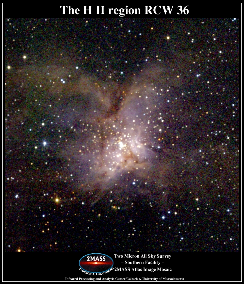
The RCW 36 cluster can be seen in this 2MASS infrared image.
Avedisova places RCW 36 in star formation region SFR 265.12+1.44 with 43 components, including 2 masers, 11 infrared sources, the globule FeSt 2-42 and the reflection nebulae Bran 210A-C.
The RCW 36 cluster can be seen in this 2MASS infrared image.
The main ionising star for RCW 36 is [MLG2003] IRS 34 68.[1]
"The RCW 36 cluster has at least 350 members and a cluster radius of 0.5 pc, and the radial profile of the stellar surface number density can be well fitted with King profiles better than with 1/r profiles. In the central 0.1 pc x 0.1 pc region of the RCW 36 cluster, the stellar surface number density is approximately 3000 stars pc−2 This is much higher than most of the young clusters within 1 kpc of the Sun." Estimated to be 2-3 million years old.[2]
"The RCW 36 cluster has at least 350 members and a cluster radius of 0.5 pc, and the radial profile of the stellar surface number density can be well fitted with King profiles better than with 1/r profiles. In the central 0.1 pc x 0.1 pc region of the RCW 36 cluster, the stellar surface number density is approximately 3000 stars pc−2 This is much higher than most of the young clusters within 1 kpc of the Sun." Estimated to be 2-3 million years old.[2]
Notes
1. ^ Massi, F., Lorenzetti, D., & Giannini, T. (2003). "Star formation in the Vela molecular clouds. V. Young stellar objects and star clusters towards the C-cloud", Astronomy and Astrophysics, Vol. 399, 147-167. [2003A&A...399..147M]
2. ^ Baba, D., Nagata, T., Nagayama, T., et al. (2004). "Deep Near-Infrared Imaging toward the Vela Molecular Ridge C. I. A Remarkable Embedded Cluster in RCW 36", The Astrophysical Journal, Vol. 614, 818-826. [2004ApJ...614..818B]
Distance estimates
700 pc [2004ApJ...614..818B]Links
[ DSS | ADS | ADS Abstract ]
map | book | blog | gallery | sources

Most of the sources used to create these nebula descriptions are listed in the
notes section for each description. In some cases,
for example the Avedisova, Humphreys and Reed catalogs, the source is used extensively and is not listed in the
individual nebula descriptions. See this catalog overview
for more information on the catalogs and the general sources used
to create these descriptions and this introduction to HII regions
on the general history of this area of astronomy.
This image was created using the POSS-II/UKSTU data of the Digitized Sky Survey and SuperCOSMOS using the process described here.
According to my correspondence with the Royal Observatory Edinburgh and the Space Telescope Science Institute, I am allowed to use the POSS-II/UKSTU data to create and display images for non-commercial purposes so long as I include this fine print for the SuperCOSMOS data:
Use of these images is courtesy of the UK Schmidt Telescope (copyright in which is owned by the Particle Physics and Astronomy Research Council of the UK and the Anglo-Australian Telescope Board) and the Southern Sky Survey as created by the SuperCOSMOS measuring machine and are reproduced here with permission from the Royal Observatory Edinburgh.
and this acknowledgement taken from the DSS site:
The Digitized Sky Surveys were produced at the Space Telescope Science Institute under U.S. Government grant NAG W-2166. The images of these surveys are based on photographic data obtained using the Oschin Schmidt Telescope on Palomar Mountain and the UK Schmidt Telescope. The plates were processed into the present compressed digital form with the permission of these institutions.
The Second Palomar Observatory Sky Survey (POSS-II) was made by the California Institute of Technology with funds from the National Science Foundation, the National Geographic Society, the Sloan Foundation, the Samuel Oschin Foundation, and the Eastman Kodak Corporation.
The UK Schmidt Telescope was operated by the Royal Observatory Edinburgh, with funding from the UK Science and Engineering Research Council (later the UK Particle Physics and Astronomy Research Council), until 1988 June, and thereafter by the Anglo-Australian Observatory. The blue plates of the southern Sky Atlas and its Equatorial Extension (together known as the SERC-J), as well as the Equatorial Red (ER), and the Second Epoch [red] Survey (SES) were all taken with the UK Schmidt.
The "Second Epoch Survey" of the southern sky was made by the Anglo-Australian Observatory (AAO) with the UK Schmidt Telescope. Plates from this survey have been digitized and compressed by the ST ScI. The digitized images are copyright ? 1993-5 by the Anglo-Australian Observatory Board, and are distributed herein by agreement.
The "Equatorial Red Atlas" of the southern sky was made with the UK Schmidt Telescope. Plates from this survey have been digitized and compressed by the ST ScI. The digitized images are copyright ? 1992-5, jointly by the UK SERC/PPARC (Particle Physics and Astronomy Research Council, formerly Science and Engineering Research Council) and the Anglo-Australian Telescope Board, and are distributed herein by agreement.
The compressed files of the "Palomar Observatory - Space Telescope Science Institute Digital Sky Survey" of the northern sky, based on scans of the Second Palomar Sky Survey are copyright ? 1993-1995 by the California Institute of Technology and are distributed herein by agreement. The compressed files of the "Palomar Observatory - Space Telescope Science Institute Digital Sky Survey" of the northern sky, based on scans of the Second Palomar Sky Survey are copyright ? 1993-1995 by the California Institute of Technology and are distributed herein by agreement.